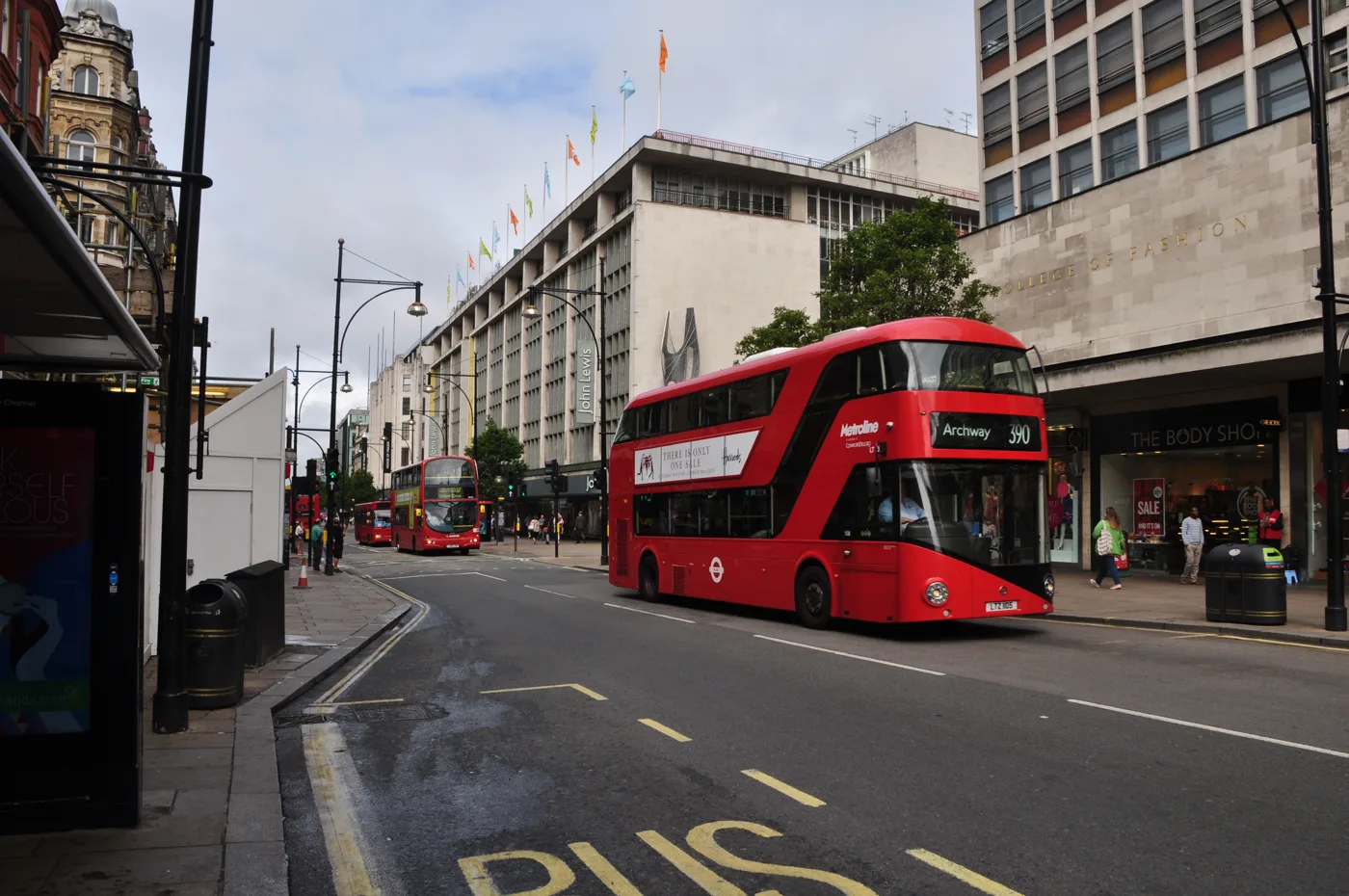

The Mayor's target was traffic-free by the end of summer. On 1 September buses 94, 139 and 390 still stop at Selfridges, and the council wants a full EIA.
Sadiq Khan said Oxford Street would be traffic-free by the end of this summer. Summer ended yesterday.
On Monday morning Transport for London’s own route data still listed buses 94, 139 and 390 stopping at Selfridges and at Oxford Circus, on the stretch that is supposed to be cleared. Nothing has been removed yet.
Westminster City Council has now asked the Government to slow it down further. On Friday 28 August it said it had written to TfL and to the Ministry of Housing, Communities and Local Government, opposing what it describes as TfL’s request to skip a full Environmental Impact Assessment of the scheme.
What the Mayor actually approved
The decision that authorised all of this is Mayoral Decision MD3475, signed by Sadiq Khan on Thursday 26 February 2026. It approved three things:
- the proposals for pedestrianising Oxford Street between Great Portland Street and Orchard Street, the stretch TfL calls Oxford Street West
- publication of TfL’s consultation report
- a direction to TfL to implement the removal of traffic from that stretch
The delivery timetable in the decision is a single line: removal of traffic from Oxford Street West in “Summer 2026, subject to approvals”. The Mayor’s own announcement on 4 March 2026 put it as traffic-free “by the end of this summer”.
Neither document names a date in September or beyond. Neither says what happens if the approvals are not in place in time.
What the council is asking for
The council’s position, published on 28 August, is not that the scheme should be stopped. It is that it should be assessed properly first.
Cllr Tim Barnes, Deputy Leader of Westminster City Council, said: “Our position on pedestrianisation is simple, if you must to do it, get it right.” He added: “This scheme will have an impact way beyond Oxford Street affecting bus routes and traffic flow right across the capital.”
The council wants an assessment covering traffic, noise, air quality, waste management and public safety. Cllr Barnes said the Mayor “has important questions to answer about managing traffic, noise, impact on air quality or how to clean the roads”, and that “London deserves a world class shopping district at its centre and instead we’re headed for an unmanaged mess.”
Two things are worth being precise about. The account of TfL asking to bypass a full assessment is the council’s, and TfL has not published the request itself. The council’s statement does not say when the ministry is expected to answer.
TfL has already published modelling. It is not nothing, and it is not an EIA
The gap the council is pointing at is narrower than the press release suggests, because TfL published air quality and noise modelling alongside the consultation. Its figures are specific, and some of them are less flattering than the headline.
On noise, TfL’s decision paper says the largest reductions “would be expected on Oxford Street, Bryanston Street and James Street; these streets would see noise reduce by between 11.1 and 24.1 decibels”.
On nitrogen dioxide, the modelling works from named receptors rather than street averages:
- the highest 2024 level in the study area was 49.1 µg/m³ at London Park School, above the 40 µg/m³ limit
- by 2026, without the scheme, the highest is still London Park School, forecast at 42.6 µg/m³, still above the limit
- the largest increase the scheme is modelled to cause is 2.1 µg/m³, at a ground-floor residence on Upper Brook Street in Mayfair
- the largest decrease is 3.5 µg/m³, at a first-floor residence on Oxford Street west
In other words, the scheme moves pollution rather than removing it, which is exactly the displacement the council is complaining it has not seen tested. TfL’s own conclusion is that levels at exceeding sites “will continue to decline”, driven by background trends and existing policy rather than by this scheme.
The carbon numbers make the same point.
The buses are the part residents will feel
Five daytime routes run along Oxford Street West: 7, 94, 98, 139 and 390. At night the list is N7, 94, N98, N113, N137, 139, N207 and 390.
Under the scheme they are diverted away from the street, mainly onto Wigmore Street, with replacement stops sited roughly 100 to 200 metres from Oxford Street. Taxis and private hire vehicles are barred from the pedestrianised stretch. Servicing vehicles are allowed between midnight and 7am, and emergency vehicles keep access.
The preparatory work has to come first. TfL’s sequence is to change the surrounding roads so the buses can be diverted, then close Oxford Street West, then start the public realm works. That is why nothing has visibly happened on Oxford Street itself yet.
TfL’s consultation on the changes ran from November 2025 to 16 January 2026 and drew 2,716 responses. The largest single theme was general support, from 647 respondents. General opposition came from 472. Traffic congestion was raised by 439, and loss of access for disabled people by 308.
What it means for you
- Nothing has changed on the ground. As of Monday 1 September, buses 94, 139 and 390 still stop at Selfridges and Oxford Circus. Do not replan a journey on the assumption the street has closed.
- Watch Wigmore Street, not Oxford Street. The first visible sign that the scheme is starting will be roadworks on the surrounding streets to prepare the bus diversion, not a closure on Oxford Street itself. Our roadworks and travel page tracks the live TfL feed for Westminster and will pick those up.
- If you live on the displacement routes, the modelling names streets. Upper Brook Street is the receptor with the largest modelled increase. Wigmore Street is where the buses go. Neither is inside the pedestrianised stretch.
- The planning authority for Oxford Street is no longer the council. Since 10 August the Oxford Street Development Corporation decides planning applications within one block either side. See our Westminster planning news page for who decides what now.
- There is no new consultation open. The consultation closed on 16 January 2026 and the Mayor made his decision in February. The live process is the exchange between the council, TfL and the ministry over whether an EIA is required.
Sources
- Westminster City Council: Council demands full Environmental Impact Assessment on Oxford Street scheme, 28 August 2026, for the council’s letters to TfL and the Ministry of Housing, Communities and Local Government and every quote from Cllr Tim Barnes.
- Mayoral Decision MD3475, signed 26 February 2026, for what was approved, the Summer 2026 delivery line, the noise reduction range and the consultation response breakdown.
- Mayor of London: Mayor confirms next steps to make world-famous Oxford Street traffic-free by the end of this summer, 4 March 2026, for the end-of-summer target, the taxi and private hire prohibition and the servicing hours.
- TfL: Oxford Street transport and highway changes, air quality for the London Park School figures, the Upper Brook Street and Oxford Street west receptors and all three CO2 totals.
- TfL: Oxford Street proposals for transport and highway changes for the affected bus routes, the Wigmore Street diversion, the stop distances and the consultation dates.
- TfL Line Route Sequence API, checked 1 September 2026, for the routes still calling at Selfridges and Oxford Circus.
Have your say